About the Red River War
Out of the many wars that have shaped and molded the United States of America, the Red River War is one of the most aloof and even unknown. Without the battles of the Red River War and ensuing victory, the great migration west could have never taken place.
|
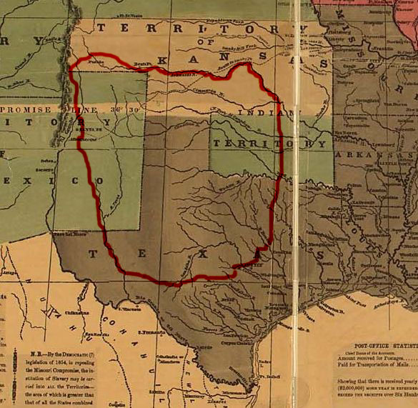
"Comancheria" was the land that was virtually untouched by Americans until after the Red River War. The Comanche Indians along with some Kiowa, Cheynne and Arapaho inhabited this part of the country and were left along throughout the time of the Civil War. |
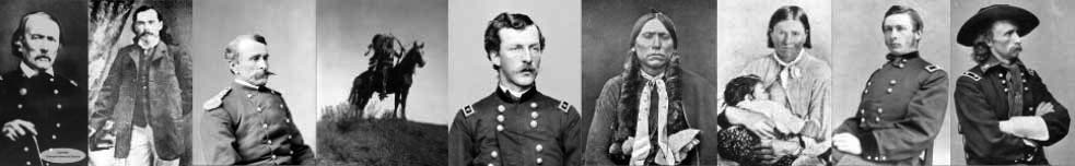
As a young boy, I grew up with many of the battles of the Red River War virtually in my back yard. Even though I was aware of one or two of them, I had no idea just how many of them took place not far from where I was raised. I had grown up hearing of Adobe Walls and two of it's famed warriors, Billy Dixon and Bat Masterson and have been to its location on several occasions. In my early junior high school years I remember hearing the story of Billy Dixon shooting a mounted Indian at almost a mile away with a borrowed Sharps buffalo rifle. I had also heard about other players in the Second Battle of Adobe Walls in 1874. Bat Masterson had been a gun slinger who was famous for his days in Dodge City and later became a sports writer for a newspaper in New York City. Quanah Parker was the famed Indian chief who led the Indians against the cowboys, or buffalo hunters more specifically that warm summer day. All of the references I read about Quanah is that his name meant "smell" or "fragrance." But according to my junior high Texas history teacher, it meant "Stink." The Indians got their names from things that were going on around them. One of the funny ones is the name of the medicine man that fateful day at Adobe Walls. His name was Isa-Tai which translates into "Coyote Anus." Isa-Tai "made medicine" and told the warriors who had gathered to attack the buffalo hunters at Adobe Walls, that if they used his special war paint that the enemy's bullets would fly right through them, never harming them. The warriors not only painted themselves but their horses also. Isa-Tai became a laughing stock of the Indians after they found out, the hard way, that his medicine was no good. Some warriors wanted to kill him but his life was spared.
I have always been a lover of history but I must admit that I had no interest in "cowboys and indians" other than playing as a young boy. What got me interested in all of this was Billy Dixon and his story. Luckily, his wife, Olive, decided to start writing down Billy's memoirs. Later she published them in a
|
The five state area of Colorado, New Mexico, Kansas, Oklahoma and Texas. |
book called, "Life of Billy Dixon". I found the book online and began to read it. I found myself staying up late through the night looking forward to every page. After finishing this book, I found George Custer's book, "My Life on the Plains", online and just like Dixon's book, I could barely put it down. I had a hook set so deeply into my jaw that nothing was going to get it out. What amazed me was how much of the Red River War wasfought so near to where I was raised and how little of it is known by Americans.
I hope you will get as excited about the history of the southern plains as I have. Even though the battle between the white man and the red man has gone on from the first step of the white man on this continent, my plan is to stay within the bounds of an eleven year period from 1864 to 1874.
I was born in 1959 in Shamrock, Texas not far from where a couple of battles in the Red River War were fought on McClellan Creek near present day Alanreed, Texas. I spent the first seven years of my life in southwestern Oklahoma. The first five years I lived in Erick, Oklahoma and the next two in Sayre, Oklahoma. Then my family moved to Spearman, Texas, almost in the center of what was once called "Comancheria".
|
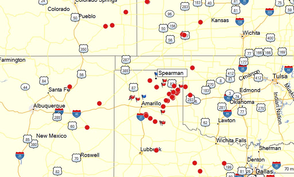
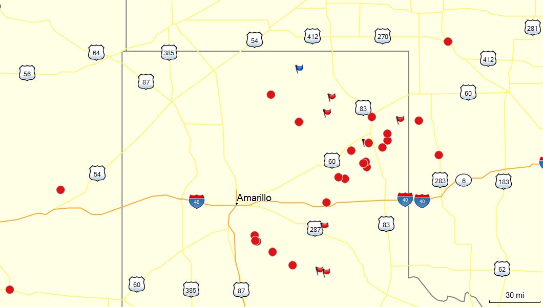
Battlesof the Red River War are marked with red dots. The blue flag toward the top of the image is where I was raised in Spearman, Texas. |
Twenty miles south of Spearman is the sight of Adobe Walls. The first battle there took place between the U.S. Army led by famed Indian figher and scout named Kit Cason and several thousand plains Indians, mostly Comanche, Kiowa, Southern Sioux and Arapaho. The second battle took place ten years later between twenty nine whites and approximately seven hundred Comanche, Kiowa, Southern Sioux and Arapaho. I have been to this location several times. On the location are monuments for the Indians and whites and Billy Dixon's grave stone.
About half way between Spearman and Stinnett, Texas on Highway 207, you turn east onto county roads and signs will take you to caliche roads that lead into the battle sight. The land is flat as a pancake with golden wheat swaying in the mighty wind looking like waves of the ocean. But as soon as you drop into the Canadian River canyon you start spotting cottonwood trees and tall green grass. It is easy to see why the Indians and buffalo hunters alike loved this land. Oil and gas wells dot the landscape. In the distance, I see several wells with their tank batteries and an occasional tanker truck. Standing near the monuments, I look up to the mesa where Dixon shot an Indian off of his horse, effectively ending the Second Battle of Adobe Walls. The location is windy but beautiful, quite and peaceful. As with most of Texas, the land surrounding the battle site is private property and the management of Turkey Track Ranch will not put up with any trespassing. Turkey Track Ranch has an extensive and interesting history almost as old as that of the battles that took place here.
How twenty nine people withstood the onslaught of seven hundred armed warriors is beyond me. Not all of the whites were hunters. Some of them were store owners. One was a white woman, the wife of one of the store owners. Some were men hired to skin the buffalos when the hunters had shot them. The Indians far outnumbered the whites and the advantage of a sneak attack was in their favor. The white men had two advantages on their side, the thick adobe that had been used to build the buildings they were in and the extremely accurate, powerful, long range weapons they used to hunt the buffalo. The battles will be covered in different sections as well as the other battles of the Red River War. I hope that I can convey the stories of these battles so that you will be as interested in this fascinating part of American history just I have been.
Important Things to Know
|
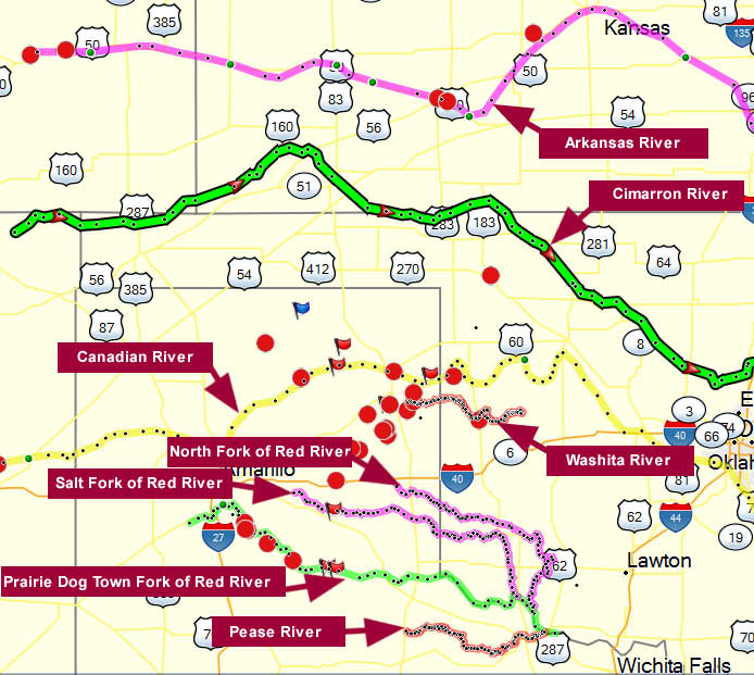
| Rivers related to the Red River War from 1864 to 1874. |
The Great Plains and especially what was called Comancheria was inhabitable to white men until the mid 1970's, being one of the last areas of this country to be populated. When studying the location of battles, local streams and rivers are referred to. Where possible, I will refer to present day towns and give lattitude and longitude. All of my lattitude and longitude readings will be in the general vicinity but they are not spot on. From 1998 to 2003, the Texas Historical Commission was able to search most of the battlegrounds of the Red River War. They used metal detectors and were able to find the exact location of most of the battles. Brett Cruse, who led this outstanding expedition told me that it took longer to convince land owners that there had been battles fought on their land than it did to find the actual locations. He also told me that a couple of land owners would not give permission to hunt for artifacts on their property. The Commission was able to locate over 3,700 artifacts that had laid, largely untouched, for as long as 125 years.
The rivers that will be referred to in this study all run from west to east. The furtherst north is the Arkansas River. It flows east from Colorado through Kansas, Oklahoma and Arkansas before flowing into the mighty Mississippi. Dropping south, in order, are the Cimarron River, the Canadian River, the Washita River, the North Fork of the Red River, the Salt Fork of the Red River, the Prairie Dog Town Fork of the Red River and the Pease River. When local creeks or streams are referred to, I will do my best to give approximate locations.
Rivers
The Arkansas River - starts in Colorado and flows east and southeast through Colorado, Kansas, Oklahoma and Arkansas before emptying into the Mississippi River. It is the sixth longest river in the United States at 1,469 miles. Fort Dodge and Dodge City in Kansas were built near the river.
The Cimarron River - begins near Johnson's Mesa near Folsom, Colorado flowing 698 miles. It enters the Oklahoma Panhandle near Kenton, crosses the southeastern corner of Colorado into Kansas, re-enters the Oklahoma Panhandle, re-enters Kansas, and finally returns to Oklahoma where it joins the Arkansas River at Keystone Reservoir west of Tulsa, Oklahoma.
The Canadian River - the longest tributary of the Arkansas River, it begins in Colorado, dropping down through New Mexico, through the Texas Panhandle and through most of Oklahoma. The river joins the Arkansas about forty miles west of the Arkansas line.
The Washita River - begins in Hemphill County, Texas some twelve or thirteen miles south, southeast of Canadian, Texas. It flows into Oklahoma and empties into Lake Texhoma in south central Oklahoma.
The North Fork of the Red River - begins in Gray County, Texas and flows 291 miles south, southeasterly across the Texas Panhandle and Oklahoma, joining the Red River near Frederick, Oklahoma and Vernon, Texas.
The Salt Fork of the Red River - begins north of Claude, Texas and flows 193 miles east and southeastwardly through the Texas Panhandle and Oklahoma. It joins the Prairie Dog Town Fork of The Red River about 13 miles south of Altus, Oklahoma.
The Prairie Dog Town Fork of The Red River - is a sandy-braided stream about 120 miles long, formed at the confluence of Palo Duro Creek and Tierra Blanca Creek, about 1.8 miles northeast of Canyon in Randall County, Texas, and flowing east-southeastward to the Red River about 1.6 km (1 mi) east of the 100th meridian, 8 miles south-southwest of Hollis, Oklahoma.
The Pease River - begins about 20 miles northeast of Paducah, Texas and flows about 100 miles east where it joins the Red River about 8 miles northeast of Vernon, Texas. In December 1860, the Texas Rangers recaptured Cynthia Ann Parker, mother of the last great Comanche war chief, Quanah Parker, and her daughter from the Comanche Indians at an engagement along the river. |